California's rainy season has been living up to its name this year as more storms will continue to impact the state for the next several days.
I hate to sound like a broken record, but heavy rain, mountain snow and gusty winds are the main factors again for the waterlogged state.

Timing of Storms
Through Sunday: The first rounds of moisture will continue through the weekend, spreading across much of the state. The heaviest rainfall is expected across Northern California, with flood watches lasting through Sunday. Heavy snowfall is expected across the Sierra Nevada. High wind alerts are in place for most of Northern California, stretching to parts of Southern California.

Monday: Another storm system will approach, bringing another round of rain, snow and wind. This system is currently forecast to be weaker than the ones over the weekend, with only a level 1 of 4 threat of excessive rainfall for much of coastal California.
Tuesday: Much of the state will see drier conditions since the bulk of the lower-elevation rain and mountain is focused across the Pacific Northwest. Only Northern California can see some valley rain and mountain snow.
Wednesday - Friday: The forecast starts to get more uncertain here with some models showing signs of another storm system or two. Our data does show more rain and mountain snow for Northern California for at least Wednesday before the state will dry out by the weekend. Check back with us frequently as the forecast may change.
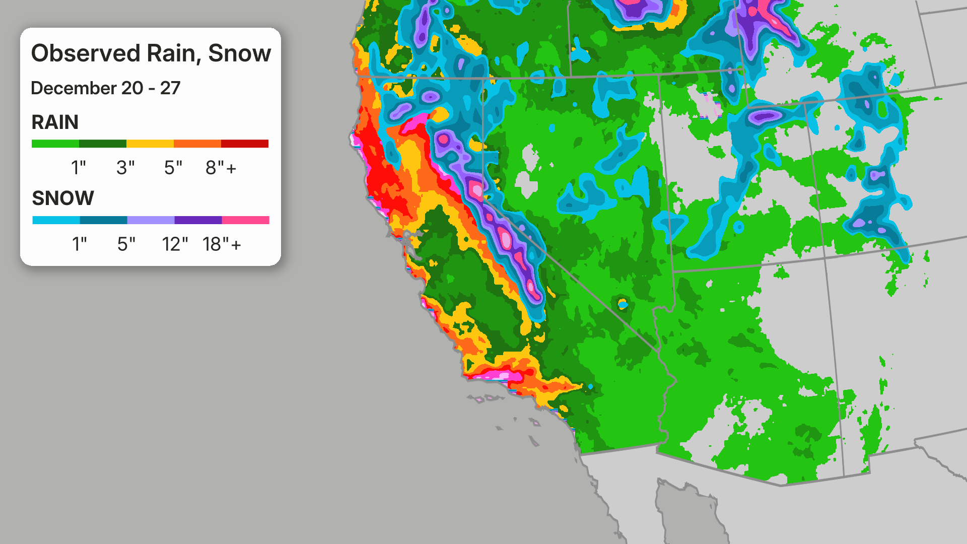
How Much Rain And Snow?

Widespread rainfall totals of 2-4 inches are possible with the Sierra foothills seeing 5-7 inches. Widespread winds to 50 mph could also cause some power outages and downed tree limbs.
Across the Sierra Nevada, snowfall totals through Monday morning could reach up to 5 feet. Winds could reach 100 mph across the peaks, so traveling in the mountains could be difficult to impossible.
Additional rain and mountain snow are expected from the systems this upcoming week. More details will be added as the forecast narrows.
Above Average Rainfall
This is the rainy season across the West, so if there were no rainfall, we would have a problem.
But, if you are wondering if it has been more than normal, you are correct.
We are seeing above-average rainfall this season. Let me give you a few cities below:
Los Angeles has seen an impressive 13.25 inches of rainfall since October 1. Their average is just over 4 inches. In fact, this is their 4th wettest October to January they have ever seen. A large portion of this rainfall fell the week of Christmas (see below graphic).
For More:Atmospheric River Recap)
Downtown San Francisco has seen nearly 10 inches of rainfall since October 1. Not as impressive as Los Angeles, but the city is still running over an inch above average.
Redding has seen over 16 inches of rainfall since October 1, which is over 4 inches above average.
Snowpack Recovering
The California Snowpack is essential, not just for skiers but for the fresh water supply for the state.
And when the snowpack is underperforming, concern mounts.
This year was not off to a good start.
On December 19, 2025, the snowpack was just 12% of where it should have been, largely due to the above-average warmth that has been persisting across parts of the West this winter. The warmth only allowed snowfall across the highest elevations.
This pattern has shifted, and as of January 2, 2026, the snowpack has jumped to 69% of normal. Nature has work to do, but hopefully the latest snowfall will bring it even closer to average.

King Tides Impacts?
If the rounds of rain, snow and gusty winds weren't bad enough, California is also being impacted by King Tides.
King Tides typically occur when the moon is near full and at its closest point to Earth and can create devastating storm surge.
(MORE:King Tides)
Coastal flood alerts are in place across parts of California over the weekend, warning that potentially 2 feet or higher of inundation is possible, which could lead to flooding of coastal communities.
Rob Shackelford is a meteorologist and climate scientist at weather.com. He received his undergraduate and master's degrees from the University of Georgia studying meteorology and experimenting with alternative hurricane forecasting tools.


0 Comments